A map is one of the most powerful tools for understanding a country. When it comes to Morocco, maps reveal far more than borders and city names. They tell a story of mountain ranges rising sharply from fertile plains, deserts stretching endlessly to the horizon, and bustling cities that have served as crossroads of cultures for centuries. Whether you are a traveler planning a route through Marrakech and Fes, a student studying African geography, or simply someone curious about North Africa, a Morocco map provides the perfect entry point into the nation’s landscapes, regions, and history.
In this comprehensive guide, we will explore Morocco through its different maps—political, physical, climatic, historical, and touristic. Each map highlights a unique perspective, allowing us to see not only where things are but also how geography has shaped Morocco’s people, culture, and economy.
Table of Contents
Where Morocco Is on the Map
Morocco is located in Northwest Africa, occupying a strategic position at the meeting point of the Atlantic Ocean and the Mediterranean Sea. Its northern coast faces Spain across the Strait of Gibraltar, making it a natural link between Europe and Africa. To the east lies Algeria, while the vast Sahara Desert stretches southward. This location has made Morocco both a gateway and a barrier, blending influences from Africa, Europe, and the Middle East.
On a world map, Morocco stands out for this geographical duality: oceanic on one side, Saharan on the other. This contrast is a recurring theme you will notice across its political and physical maps.
Political Map of Morocco
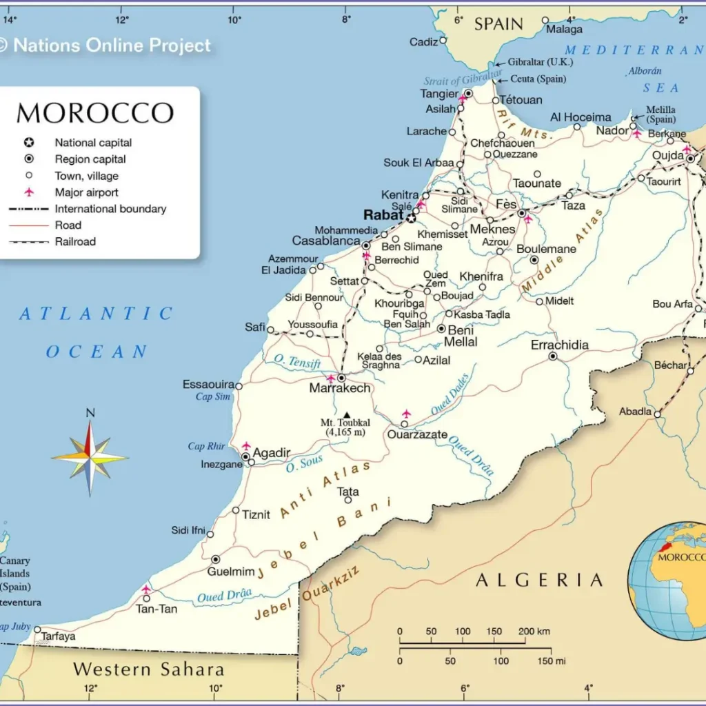
A political map shows boundaries, administrative divisions, and cities. Morocco’s political organization is based on 12 regions, each with its own capital and governor. These regions are further subdivided into provinces and prefectures.
Regions of Morocco, Their Capitals, Prefectures, and Provinces
| Region | Regional Capital | Prefectures and Provinces |
|---|---|---|
| L’Oriental | Oujda-Angad | Oujda-Angad, Nador, Driouch, Jerada, Berkane, Taourirt, Guercif, Figuig |
| Marrakech-Safi | Marrakech | Marrakech, Chichaoua, Al Haouz, Kelâa des Sraghna, Essaouira, Rehamna, Safi, Youssoufia |
| Drâa-Tafilalet | Errachidia | Errachidia, Ouarzazate, Midelt, Tinghir, Zagora |
| Fès-Meknès | Fès | Fès, Meknès, El Hajeb, Ifrane, Moulay Yacoub, Sefrou, Boulemane, Taounate, Taza |
| Guelmim-Oued Noun | Guelmim | Guelmim, Assa-Zag, Tan-Tan, Sidi Ifni |
| Tanger-Tétouan-Al Hoceima | Tanger-Assilah | Tanger-Assilah, M’diq-Fnideq, Tétouan, Fahs-Anjra, Larache, Al Hoceima, Chefchaouen, Ouazzane |
| Souss-Massa | Agadir Ida-Ou-Tanane | Agadir Ida-Ou-Tanane, Inezgane-Aït Melloul, Chtouka-Aït Baha, Taroudannt, Tiznit, Tata |
| Casablanca-Settat | Casablanca | Casablanca, Mohammadia, El Jadida, Nouaceur, Médiouna, Benslimane, Berrechid, Settat, Sidi Bennour |
| Dakhla-Oued Eddahab | Oued Ed-Dahab | Oued Ed-Dahab, Aousserd |
| Béni Mellal-Khénifra | Béni Mellal | Béni Mellal, Azilal, Fquih Ben Salah, Khénifra, Khouribga |
| Rabat-Salé-Kénitra | Rabat | Rabat, Salé, Skhirate-Témara, Kénitra, Khémisset, Sidi Kacem, Sidi Slimane |
| Laâyoune-Sakia Al Hamra | Laâyoune | Laâyoune, Boujdour, Tarfaya, Es-Semara |
Physical Map of Morocco
A physical map emphasizes the land’s natural features: mountains, rivers, plains, and deserts. Morocco is among the most geographically diverse countries in Africa, and this variety is striking when seen on a physical map.
- Atlas Mountains: Divided into the High Atlas, Middle Atlas, and Anti-Atlas, these ranges dominate central Morocco. They create dramatic landscapes and act as climatic barriers.
- Rif Mountains: Located in the north, close to the Mediterranean coast, known for rugged terrain and fertile valleys.
- Sahara Desert: The southern and southeastern part of Morocco transitions into the Sahara, with iconic dunes like Erg Chebbi near Merzouga.
- Plains and Plateaus: Between the mountains and the coast lie fertile plains, such as the Chaouia and Tadla regions, which support agriculture.
- Rivers: The Oum Er-Rbia, Sebou, and Moulouya rivers sustain farming and urban life.
A physical map helps explain why Morocco’s population is concentrated in coastal and inland plains, while the desert and mountains are sparsely inhabited.
Climate and Vegetation Maps
Morocco’s climate varies dramatically, and maps showing climate zones reveal these contrasts.
- Mediterranean Climate: Along the northern and western coasts, with mild wet winters and hot summers.
- Continental Climate: Inland areas such as Fes and Meknes, with greater temperature extremes.
- Mountain Climate: The Atlas Mountains see cold winters with snow, supporting ski resorts like Oukaïmeden.
- Desert Climate: Southern Morocco is dry and hot, with minimal rainfall.
Vegetation maps show fertile farmlands in the north and central plains, cedar forests in the Middle Atlas, and arid desert vegetation in the south.
Tourist Maps of Morocco
For visitors, tourist maps are invaluable. These maps highlight:
- Major cities: Marrakech, Casablanca, Rabat, Fes, Tangier, Agadir.
- UNESCO World Heritage sites: Medina of Fes, Ait Benhaddou, Meknes, and others.
- Natural attractions: Atlas Mountains, Todra Gorge, Sahara Desert dunes.
- Coastal destinations: Essaouira, Agadir, Tangier.
- Transport routes: Highways, railways, and airports.
Tourist maps often combine political and physical features with icons marking attractions, making them more practical for planning itineraries.
Regional Maps and Local Highlights
Each region of Morocco has unique characteristics, and regional maps help uncover them.
- Northern Morocco: Tangier and Tetouan connect Morocco with Spain. The Rif Mountains dominate the landscape.
- Central Morocco: Rabat, Casablanca, and Fes form an economic and cultural triangle.
- Southern Morocco: Marrakech and Agadir open the way to the Atlas and the Sahara.
- Southeastern Morocco: Ouarzazate, known as the “Hollywood of Morocco,” and the desert dunes near Merzouga.
By studying regional maps, travelers can better appreciate distances, road connections, and landscapes.
Road and Transport Maps
Morocco has an extensive road and rail network. Road maps highlight major highways like the A1 (Tangier to Casablanca) and A3 (Casablanca to Marrakech). The national railway network, ONCF, connects major cities from Tangier in the north to Marrakech in the south.
These maps are especially important for planning self-drives or overland trips, as they show distances, road conditions, and gas stations.
Maps for Education and Research
Educational maps of Morocco serve schools and universities. Blank outline maps are used for learning geography, while detailed maps support research in climate, geology, and urban planning. Teachers often use printable maps to illustrate lessons about Africa’s geography.
Maps and Culture: More Than Geography
Maps in Morocco are not just functional; they reflect culture and identity. Traditional cartography, colonial influences, and modern GIS technology all shape how Morocco is represented. Some maps include Arabic and Berber names, reflecting the nation’s linguistic diversity.
Practical Uses of Morocco Maps
- Travel Planning: Choosing routes, estimating distances, finding attractions.
- Education: Learning geography, history, and climate.
- Business and Trade: Understanding logistics, ports, and transport networks.
- Research: Mapping biodiversity, land use, and urban expansion.
Western Sahara on the Map
No discussion of Morocco’s maps is complete without Western Sahara. Different maps portray it differently: some mark it as part of Morocco, while others show it as a disputed territory. This makes map selection politically sensitive, especially in international publications.
Future of Digital and Interactive Maps
With GPS and smartphones, interactive maps are now essential. Applications like Google Maps, OpenStreetMap, and GIS layers allow users to zoom in on Morocco’s streets, hiking trails, or remote desert pistes. Future maps may integrate augmented reality, showing monuments and routes in real time.
Google Maps – Morocco
Google Maps – Morocco is one of the most practical tools for exploring the country, whether you’re planning a trip, studying geography, or just curious about its landscapes. The platform allows you to zoom in on every region of Morocco, from bustling cities like Casablanca, Marrakech, and Rabat to remote areas such as the Sahara Desert and the Atlas Mountains.
With satellite views, terrain details, and street-level imagery, Google Maps offers an interactive way to understand Morocco’s diverse geography. Travelers can easily find routes between cities, check estimated travel times, and discover restaurants, hotels, and landmarks. It’s also a useful educational resource for identifying Morocco’s borders, regions, and major transport networks.
Whether you’re preparing for an adventure or learning about Morocco from afar, Google Maps provides an accurate, user-friendly perspective of the country.
Conclusion
A map of Morocco is more than a set of lines and labels—it is a window into a country of extraordinary contrasts. From snow-capped mountains to scorching deserts, from ancient medinas to modern highways, Morocco’s geography is as diverse as its culture.
Political maps explain its regions and governance. Physical maps reveal the power of nature. Tourist maps guide travelers to vibrant souks and golden dunes. Historical maps remind us of Morocco’s shifting borders and long legacy. Together, they create a complete picture of a nation that bridges continents and cultures.
Whether you are holding a paper atlas, downloading a printable PDF, or exploring Morocco through an interactive app, each Morocco map offers a new perspective. To truly understand the country, one must keep looking at its maps—again and again, from every angle.